You can’t get there from here!
The caller’s words were succinct: “We don’t know where we are, but our car is scraping bottom and it’s getting dark and we need help.”
Two 20-something women from a faraway state, driving a woefully inadequate Honda Pilot, were deeply embedded in our wilderness and knew only that they had gotten there “because that’s the way our GPS told us to go.” It wasn’t possible to assist them until morning. “You mean…” the caller faltered, “…we have to be out here all night by ourselves?”
Yes. You do. And it will earn you bragging rights back in Iowa.
These two women were in good health, and had water and food. About to taste their first back-country ‘camping,’ they slept in their car; coordinates from their iPhone provided the only way to find them, because they didn’t have a map. They were fortunate to have been able to climb up a high knoll to get a shred of cell signal.
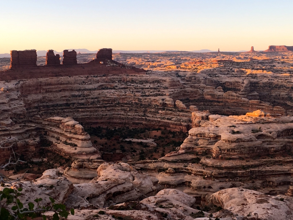
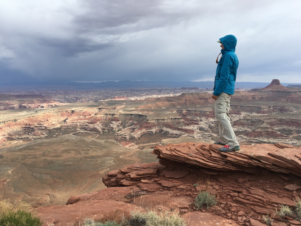
Where outlaws hid successfully. It’s called “The Maze” for very good reason.
The next visitors led astray by blindly following their GPS were driving a low-clearance rental mini-van and spoke no English. The group of seven intended to drive 45 minutes to visit the gentlest district of Canyonlands, but their device brought them a half-day’s drive to the wild and remote Maze district. We got them turned around just before a huge thunderstorm would have trapped them and their 2WD vehicle.
My friends Cowboy Steve and Diablo say: “Always carry a suitable map.”
The latest episode was the most dangerous. A lone visitor typed in “Canyonlands” and the GPS took her, in a small Ford Fiesta, deep into the interior. She was stuck in sand with no shovel, no food. It was our hottest month and she ended up walking 20 miles back to the ranger station for help; with little water, she was compelled to drink her own urine to survive the trek. She could have died trusting her GPS.
Incidents like this are rapidly increasing in frequency; our large warning signs saying ‘GPS ALERT’ go unread. The common thread is that paper maps are absent, and drivers assume that their GPS must be correct even when all evidence repudiates that.
I cannot stress enough the importance of having — and knowing how to read — good maps. DO NOT rely on devices. Too much is at stake in wilderness navigation.
Has your GPS has ever led you into trouble? Leave a comment!

And it’s not just in the boonies that GPS directions do not relate to the real world. I volunteer in a building that is about one hundred yards off of SR 95, within the city limits of Lake Havasu City AZ. Give this building’s legal address for USPS, FEDEX, DHL or United Parcel Service everything gets delivered promptly – thus they can find us. Recruits from out of town/state reporting for training plug the same address into good old GPS and it directs them to the middle of the Bill Williams River bridge (over which SR 95 crosses the river) some 15 miles south of the simple right hand turn lane, in town, that would dump our confused recruits into our front parking lot. GPS is not reliable in and around Phoenix AZ either. Me, I’m 72 years young, I love maps and go nowhere with out lots of them going from general area to the more specific. In the boonies I like quadrangles and I study them in the comfort of my home before my tires make the first revolution. The good Lord worked overtime to protect the two individuals you mention. They could so easily have joined the realm of those who are “missing” – with the likelihood of discovery, even of remains, being very slim at best.
Love your posts, you are an accomplished writer. When you retire you might consider combining them into a book. They are interesting, witty and factual! R/Lee in Lake Havasu City AZ
Comment by Lee Borgen — August 1, 2016 @ 5:07 pm |
Thank you, Lee, for sharing your GPS story and for your kind comments. I’d write posts even if I had no readers — just so I can remember things in the future — but it is lots of fun to have readers along who can add so much. Keep adding to your map collection!
Comment by Kathryn Colestock-Burke — August 2, 2016 @ 8:53 am |
We called our first GPS “Mrs. Robinson”. I never liked or trusted her. If someone was going to tell my husband where to go it was going to be me. I’ve lost connections while trying to find a soccer field, causing us to be late for the game. Give me a good paper map any day. I can tell what’s ahead & what to look for.
Comment by Brenda — August 1, 2016 @ 7:05 pm |
You won’t need an elusive signal while staring at a paper map! However, many millennials eschew them in favor of devices — the paper maps I pull out puzzle them, and their phones are their preferred navigators. I’m watching with great interest to see how this goes in the next 5-10 years.
Comment by Kathryn Colestock-Burke — August 2, 2016 @ 8:59 am |
Oh my…that’s really scary. I’m glad all of those situations turned out OK. I have a love hate with the GPS. Just a couple weeks ago we were in Twin Falls, ID trying to get to Shoshone Falls. Our GPS led us to the top of the falls, which is in the middle of a private neighborhood. The tourist platform is across the canyon. Our GPS didn’t know different. It took us as quick as it could to the falls. I was once again reminded that even in populated areas my GPS is not always accurate.
Comment by The Road We've Traveled — August 1, 2016 @ 9:40 pm |
Thanks for another excellent example. A GPS isn’t sentient. It doesn’t know what car you’re driving, whether the road is an old disused mining road, or whether you’re on the private side of Shoshone Falls. They are a powerful tool but no substitute for paper maps!
Comment by Kathryn Colestock-Burke — August 2, 2016 @ 8:48 am |
GPS and Google maps are just tools and if you don’t know how to use them or blindly follow their suggestions you are setting yourself up for trouble. Given the strange routes GPS gives me in the city I don’t trust them in the back country but use them with other navigational tools like paper maps and common sense. I do get lost on back roads from time to time and it is always my fault. An example from this spring I was following an old cutoff trail on the California Trail in Idaho. After a wrong turn at a split in the road and increasingly sketchy conditions I found a place I could stop and fire up the GPS and confirm where I was on my paper map. Well the last firmware upgrade had cleared out the maps I had preloaded into it. Ok so it could give me Lat and Long so I could plot my location on paper and decided that the road ahead was too much risk for me given that I had a trailer and was by myself and if the road got worse I’d have a heck of a time getting back out. Long story short, my false sense of confidence at an intersection on a back road was to blame. The road I should have been on was the lesser traveled and overgrown one and if I got out of the car and looked around for a minute or two I would have found the sign post with a forest rd route number on it. Instead I followed the road that look more travelled. It was more travelled for 2 miles then nothing. Lesson learned, If you have not been there before, stop at the intersections and confirm where you are. I should note that this was an hour from my house and I am relatively familiar with the area. In Southern Utah it’s a different story, I always confirm that digital devices are preloaded and working and charging cables are included, I bring all the paper maps for the area and enough gear to spend 2 nights of unexpected camping. Glad to hear that the visitors were rescued and yes they will have a story to tell.
Comment by Andrew McAllister — August 2, 2016 @ 10:49 am |
Really good advice, Andrew, and interesting that the less-traveled route was the correct one. Our motto in the Maze is, simply: BE PREPARED. For anything. That means maps, food, gear for changing weather conditions, more water than you think you need, and of course someone who has your travel itinerary.
Comment by Kathryn Colestock-Burke — August 2, 2016 @ 11:20 am |
Back in the day when I was working for a church, I used Map Quest to find routes for a new pastor. After getting directions to take a supposed through road that I knew had no bridge over a river, I just used my knowledge of the area and a paper map. The advice to have food, water, gas in your car, and other necessities hit home for even urban areas when a major storm occurred almost 2 weeks ago. For several days, many areas had roads and streets impassable because of fallen trees and even whn you could drive somewhere gas stations, grocery stores, and other businesses were closed due to no electricity. Those with wells did not have electricity so they couldn’t use them. The city water intake station was knocked off line and city residents were urged to conserve water.
The notification of travel itinerary has saved people in the Boundary Waters area of the state when searches were initiated for those overdue. Nature can abruptly cancel many of the conveniences we take for granted!
Comment by Chris Youngman — August 2, 2016 @ 12:40 pm |
So: BE PREPARED isn’t just for the wilderness. What a world it would be if we lived “basically prepared” lives, at least most days. Thanks for weighing in, and I hope Duluth gets back on its feet quickly.
Comment by Kathryn Colestock-Burke — August 2, 2016 @ 4:28 pm |
Thanks for another excellent article, and outstanding advice. Too bad it can’t be made “required reading” for anyone headed out to any park!
Comment by Jim Burnett — August 2, 2016 @ 3:10 pm |
I’ve fantasized about putting up billboards on our entrance roads that say THROW YOUR GPS OUT YOUR WINDOW RIGHT NOW, but there are too many rules about billboards in the wilderness. Maybe if I present it as a life-saving measure…
Comment by Kathryn Colestock-Burke — August 2, 2016 @ 8:10 pm |
Good, important post. As a geographer I naturally rely on paper. I’ve only used GPS for a relatively few years and have found it’s not always reliable even in cities, why in the world would anyone trust technology where it doesn’t exist – in the wilderness. Yet another reason I harp on teaching more geography, making it a required subject. Just like we should all know our times tables and not rely on calculators we should all know how to read maps, even topo maps.
Comment by Ana Perry — August 2, 2016 @ 4:12 pm |
A hearty AMEN to this! Thanks for your perspective.
Comment by Kathryn Colestock-Burke — August 2, 2016 @ 4:26 pm |
Thank you for this Blog! That’s the way it is.
First: sorry! I am from Germany and my english-lessons had been a long time ago. I hope, you can read and understand, what I want to say.
Now, for us, it ist easy. We have learned: The GPS shows you a way to your destination, but you don’t know, what way. A road or a path? The GPS doesn’t know. And in most times, you don’t know, where you are, because the screen is too small.
Some years ago we drove in northern Italy and the GPS “told” us, to take a way over a bridge. We were very lucky, because the bridge was too small for our car. Behind the Bridge was no road and no way for our 2WD. So we had the chance to look in our map and find the right way…..
The second reason for using maps is: the GPS shows you the fastest or the shortest way! But never the best way. For example, my son (19) had a handball match in a city next to our hometown. He “asked” his GPS and it told him a way 25 miles longer than the best way I knew. The reason: This way was 1(!) minute faster, than the best way. I showed him the best way on the map. So, we learned that you have to look in good maps, you have to find the best way for yourself and you have to do it, before the trip starts!
And I teached my children to read maps.
Comment by stescheff — August 3, 2016 @ 5:36 am |
Excellent examples — and how helpful to know what happens in other countries, Stefan. You’ve helped me to make my point even stronger, so thanks for writing — and thanks for teaching your children to read maps!
Comment by Kathryn Colestock-Burke — August 3, 2016 @ 5:50 am |
Hallo Kathryn,
thank you for your comment.
I have one more thing to tell: If I drive with GPS, I can’t remember the way and can’t find the way back or again without the GPS.
If I drive with a map, it is no problem to find the way back or again. Without GPS I remember landmarks, trees, viewpoints, crossings, houses…..
Comment by stescheff — August 3, 2016 @ 8:41 am